|
I hereby give notice that an Extraordinary Meeting of Council will be held on:
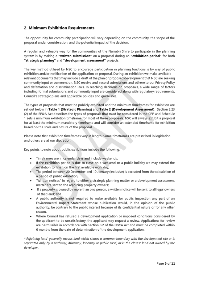
Agenda
Extraordinary Council Meeting 14 November 2019
Stewart Todd General Manager
|

|
I hereby give notice that an Extraordinary Meeting of Council will be held on:
Agenda
Extraordinary Council Meeting 14 November 2019
Stewart Todd General Manager
|
Extraordinary Council Meeting Agenda 14 November 2019
PUBLIC FORUM (held outside formal Council Meeting)
The Council may hold a public forum prior to each Ordinary Meeting of the Council for the purpose of hearing oral submissions from members of the public on items of business to be considered at the meeting (listed on the Agenda).
Public forums may also be held prior to Extraordinary Council Meetings and meetings of committees of the Council.
Public forums are to be chaired by the mayor or their nominee.
Request to Speak in the Public Forum
To speak at a public forum, a person must first make an application to the Council in the approved form. Applications to speak at the public forum must be received by 5pm on the working day before the date on which the public forum is to be held and must identify the item of business on the agenda of the Council meeting the person wishes to speak on, and whether they wish to speak ‘for’ or ‘against’ the item.
Approved speakers at the public forum are to register with the Council any written, visual or audio material to be presented in support of their address to the Council, and to identify any equipment needs at 5pm on the working day before the Public Forum.
The General Manager or their delegate may refuse to allow such material to be presented.
A person may apply to speak on no more than 2 items of business on the agenda of the Council Meeting.
Legal representatives acting on behalf of others are not to be permitted to speak at a public forum unless they identify their status as a legal representative when applying to speak at the public forum.
The General Manager or their delegate may refuse an application to speak at a public forum.
No more than three (3) speakers are to be permitted to speak ‘for’ or ‘against’ each item of business on the agenda for the Council Meeting.
If more than the permitted number of speakers apply to speak ‘for’ or ‘against’ any item of business, the general manager or their delegate may, in consultation with the mayor or the mayor’s nominated chairperson, increase the number of speakers permitted to speak on an item of business, where they are satisfied that it is necessary to do so to allow the council to hear a fuller range of views on the relevant item of business.
Each speaker will be allowed three (3) minutes to address the Council. This time is to be strictly enforced by the Chairperson.
The Chairperson of the meeting can grant one extension of up to a maximum of two (2) minutes, should further information, be considered to be important to the Council. This is solely at the discretion of the Chair.
Speakers at public forums must not digress from their nominated item on the agenda. If a speaker digresses to irrelevant matters, the Chairperson is to direct the speaker not to do so. If a speaker fails to observe a direction from the chairperson, the speaker will not be further heard.
A councillor (including the chairperson) may, through the chairperson, ask questions of a speaker following their address at a Public Forum. Questions put to a speaker must be direct, succinct and without argument. Debate will not be permitted by the speaker, Councillors or staff.
Speakers are under no obligation to answer a question. Answers by the speaker, to each question are to be limited to three (3) minutes.
Speakers at public forums cannot ask questions of the Council, Councillors or Council staff.
The general manager or their nominee may, with the concurrence of the chairperson, address the council for up 5 minutes in response to an address to the council at a public forum after the address and any subsequent questions and answers have been finalised.
Where an address made at a public forum raises matters that require further consideration by council staff, the general manager may recommend that the council defer consideration of the matter pending the preparation of a further report on the matters.
The “Request to Speak in Public Forum”, at an Ordinary Council Meeting, can be obtained, from Council’s Administration Office, or by downloading it from Council’s website at:
http://www.narrabri.nsw.gov.au/speaking-at-public-forum-1232.html
|
|
Use of mobile phones and unauthorised recording of meetings
Councillors, council staff and members of the public must ensure that mobile phones are turned to silent during meetings of the council and committees of the council.
(Clause 15.20 Code of Meeting Practice)
A person must not live stream or use an audio recorder, video camera, mobile phone or any other device to make a recording of the proceedings of a meeting of the council or a committee of the council without the prior authorisation of the Council.
(Clause 15.21 Code of Meeting Practice)
|
Mayor Cr Cathy Redding |
|||
|
Deputy Mayor Cr Cameron Staines |
Cr Maxine Booby |
Cr Ron Campbell |
Cr Ron Campey |
|
Cr Lloyd Finlay |
Cr Robert Kneale |
Cr Ann Loder |
Cr Annie McMahon |
|
General Manager Mr Stewart Todd |
Director Infrastructure Delivery Mr Darren Raeck |
Director Corporate Services Mr Lindsay Mason |
Director Development & Economic Growth Mr Daniel Boyce |


Extraordinary Council Meeting Agenda 14 November 2019
1 Opening Prayer by a Member of the Narrabri Minister’s Fraternal
3 Apologies/Granting of Leave of Absences
4 Declaration of Pecuniary and Non-Pecuniary Interests
5 Items to be Considered in the Confidential (Public Excuded) Meeting
6.1 Narrabri Shire Council Community Participation Plan
Members and officers are asked to be upstanding for the opening prayer.
I’d like to begin by acknowledging the Traditional Owners of the land on which we meet today, the Kamilaroi people, and pay my respects to Elders past and present.
Councillors are reminded of their obligation to declare their interest in any matters listed before them.
In considering your interest, you are reminded to include pecuniary, non-pecuniary and conflicts of interest as well as any other interest you perceive or may be perceived of you.
Councillors may declare an interest at the commencement of the meeting, or alternatively at any time during the meeting should any issue progress or arise that would warrant a declaration.
Councillors must state their reasons in declaring any type of interest.
|
Extract from Council’s Code of Meeting Practice Part 4 Section 17a. 17a. Which parts of a meeting can be closed to the public? (1) A Council, or a Committee of the Council of which all the members are Councillors, may close to the public so much of its meeting as comprises: (a) the discussion of any of the matters listed in Sub-Clause (2) below, or (b) the receipt or discussion of any of the information so listed. (2) The matters and information are the following: (a) personnel matters concerning particular individuals (other than Councillors), (b) the personal hardship of any resident or ratepayer, (c) information that would, if disclosed, confer a commercial advantage on a person with whom the Council is conducting (or proposes to conduct) business, (d) commercial information of a confidential nature that would, if disclosed: i. prejudice the commercial position of the person who supplied it, or ii. confer a commercial advantage on a competitor of the Council, or iii. reveal a trade secret, (e) information that would, if disclosed, prejudice the maintenance of law, (f) matters affecting the security of the Council, Councillors, Council staff or Council property, (g) advice concerning litigation, or advice that would otherwise be privileged from production in legal proceedings on the ground of legal professional privilege, (h) information concerning the nature and location of a place or an item of Aboriginal significance on community land. (3) A Council, or a Committee of the Council of which all the members are Councillors, may also close to the public so much of its meeting as comprises a motion to close another part of the meeting to the public. (4) Members of the public may be allowed to make representations to or at a Council or Committee meeting for a period of up to three (3) minutes, immediately after the motion to close the part of the meeting. (5) is moved and seconded, as to whether that part of the meeting should be closed at the discretion of the Council |

THEME 2: OUR ENVIRONMENT
STRATEGIC DIRECTION 2: ENVIRONMENTALLY SUSTAINABLE AND PRODUCTIVE SHIRE
By 2027, we will maintain a healthy balance between our natural and built environments.
COMMUNITY ENGAGEMENT
Through extensive community engagement, the Narrabri Shire community identified several environmental priority areas to be actioned over the 2017 - 2018 financial year.
COMMUNITY SERVICES
Current services provided within the Narrabri Shire community include:
§ Waste management and recycling
§ Environmental planning
§ Planning and development
§ Parks and open spaces
§ Noxious weeds control
§ Floodplain management
§ Water and sewer management
§ Stormwater management
COMMUNITY OUTCOMES
In partnership with the community, government and non-government agencies, the Operational Plan will work towards achieving the following environmental strategic outcomes:
§ Improved air, water and soil quality
§ Reduction in domestic and industry waste
§ Management of potential impacts from extractive industries
§ Improved emergency service provision and resources
§ Maintenance of heritage sites for future generation
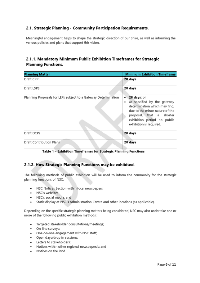
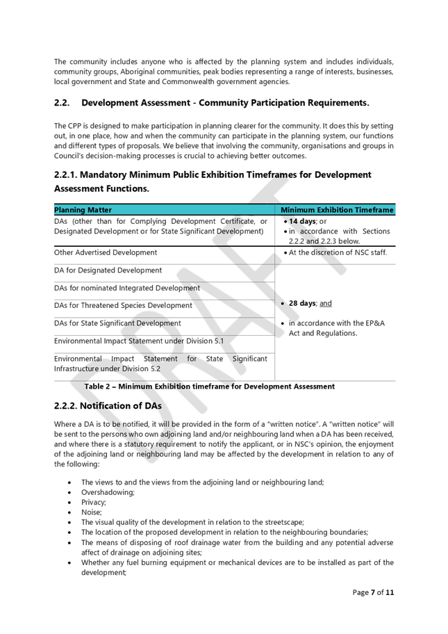
6.1 Narrabri Shire Council Community Participation Plan
Responsible Officer: Daniel Boyce, Director Development and Economic Growth
Author: Daniel Boyce, Director Development and Economic Growth
Attachments: 1. Draft Community Participation Plan ⇩
Delivery Program Alignment
|
4 Leadership |
|
|
Objective |
4.1 We will proactively engage and partner with the community and government to achieve our strategic goals |
|
Strategy |
4.1.2 Ensure the community is informed and involved in Council activities through implementing quality consultation |
Executive Summary
Planning authorities must adopt a Community Participation Plan under legislative changes to the Environmental Planning and Assessment Act 1979 (“EP&A Act”). The Community Participation Plan will set out how planning authorities will engage with their communities across their statutory planning functions.
Following resolution by Council the Narrabri Shire Community Participation Plan will be placed on public exhibition for twenty-eight (28) days. After which time, Council will receive a further report and consider any submissions.
|
1. That Council endorse the Narrabri Shire Council Community Participation Plan. 2. That Council place on exhibition the Narrabri Shire Council Community Participation Plan for a minimum period of twenty-eight (28) days. |
Background
Planning authorities must adopt a Community Participation Plan under legislative changes to the Environmental Planning and Assessment Act 1979 (“EP&A Act”). The Community Participation Plan will set out how planning authorities will engage with their communities across their statutory planning functions.
The Community Participation Plan must meet the minimum requirements for community participation that are set out in Schedule 1 to the EP&A Act, planning authorities can go beyond the minimum requirements if they decide it is appropriate.
The Narrabri Shire Community Participation Plan (attached) has been prepared in accordance with the new community participation principles outlined by the NSW Government.
Current Situation
Following resolution by Council the Narrabri Shire Community Participation Plan will be placed on public exhibition for twenty-eight (28) days. After which time, Council will receive a further report and consider any submissions.
Financial Implications
Nil.
Statutory and Policy Implications
Planning authorities must adopt a Community Participation Plan under legislative changes to the EP&A Act.
Consultation
External Consultation
Following resolution by Council the Narrabri Shire Community Participation Plan will be placed on public exhibition for twenty-eight (28) days. After which time, Council will receive a further report and consider any submissions.
Internal Consultation
· Community Relations Manager.

THEME 3: OUR ECONOMY
STRATEGIC DIRECTION 3: PROGRESSIVE AND DIVERSE ECONOMY
By 2027, we will have developed a strong, diverse economy that attracts, retains and inspires business, industry and tourism growth.
COMMUNITY ENGAGEMENT
Through extensive community engagement, the Narrabri Shire community identified several economic priority areas to be actioned over the 2017 - 2018 financial year.
COMMUNITY SERVICES
Current services provided within the Narrabri Shire community include:
§ Economic development
§ Planning and development
§ Entertainment and conferences
§ Local and regional tourism and events
§ Saleyards
§ Airport
COMMUNITY OUTCOMES
In partnership with the community, government and non-government agencies, the Operational Plan will work towards achieving the following economic strategic outcomes:
§ Increased community events, conferences and entertainment
§ Increased employment through industry innovation, investment and value adding
§ Established freight hub for the Norther Inland Region
§ Increased housing availability and affordability
§ Broadened economic base
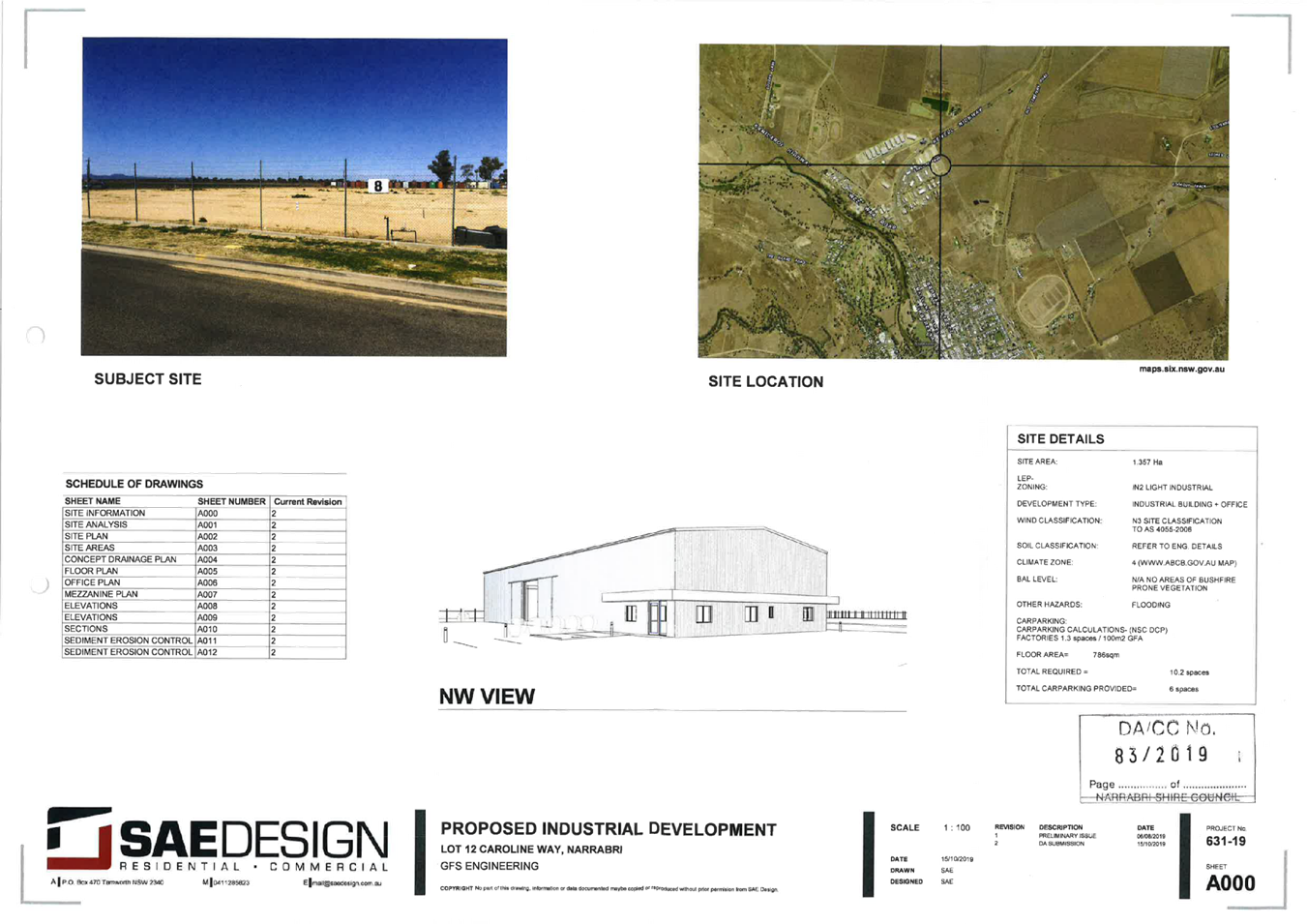
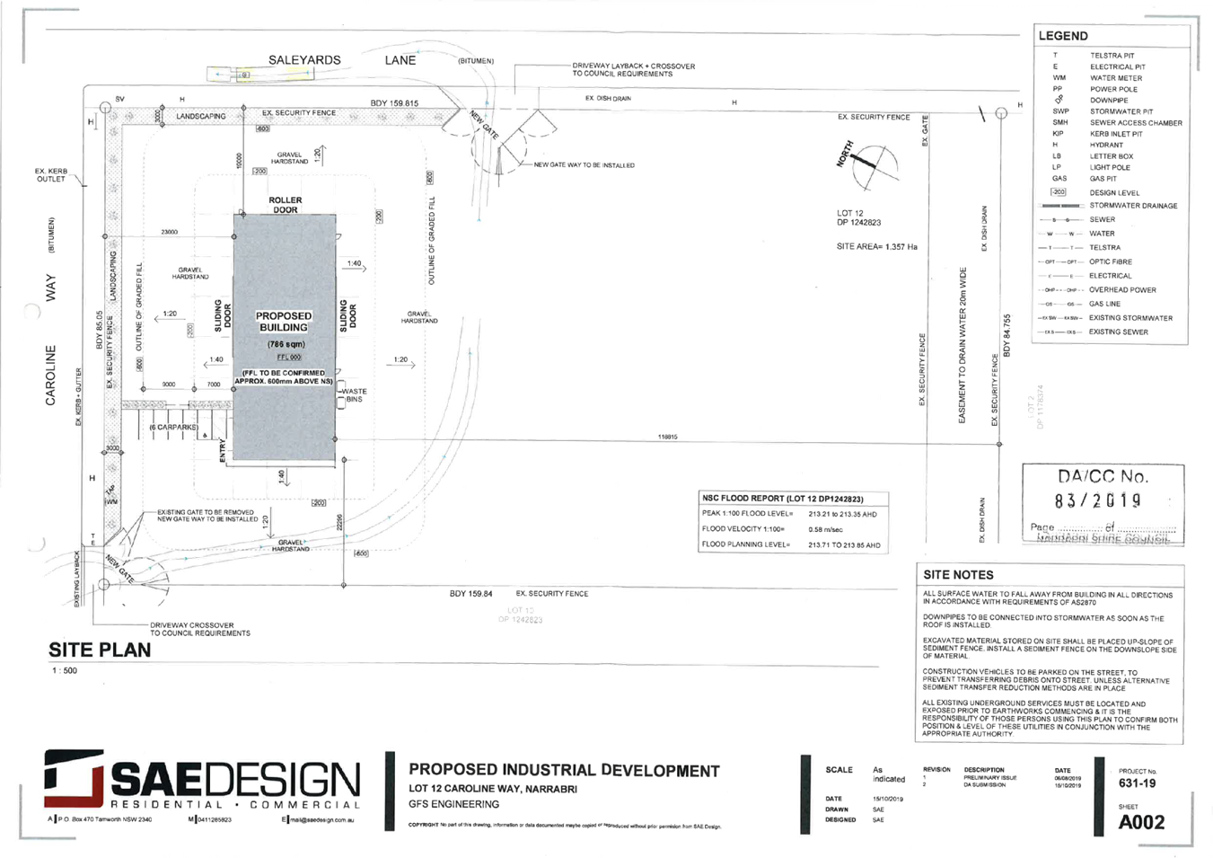
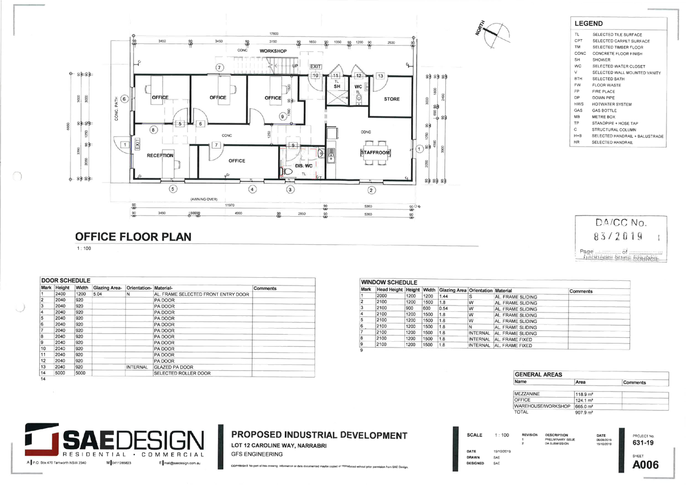
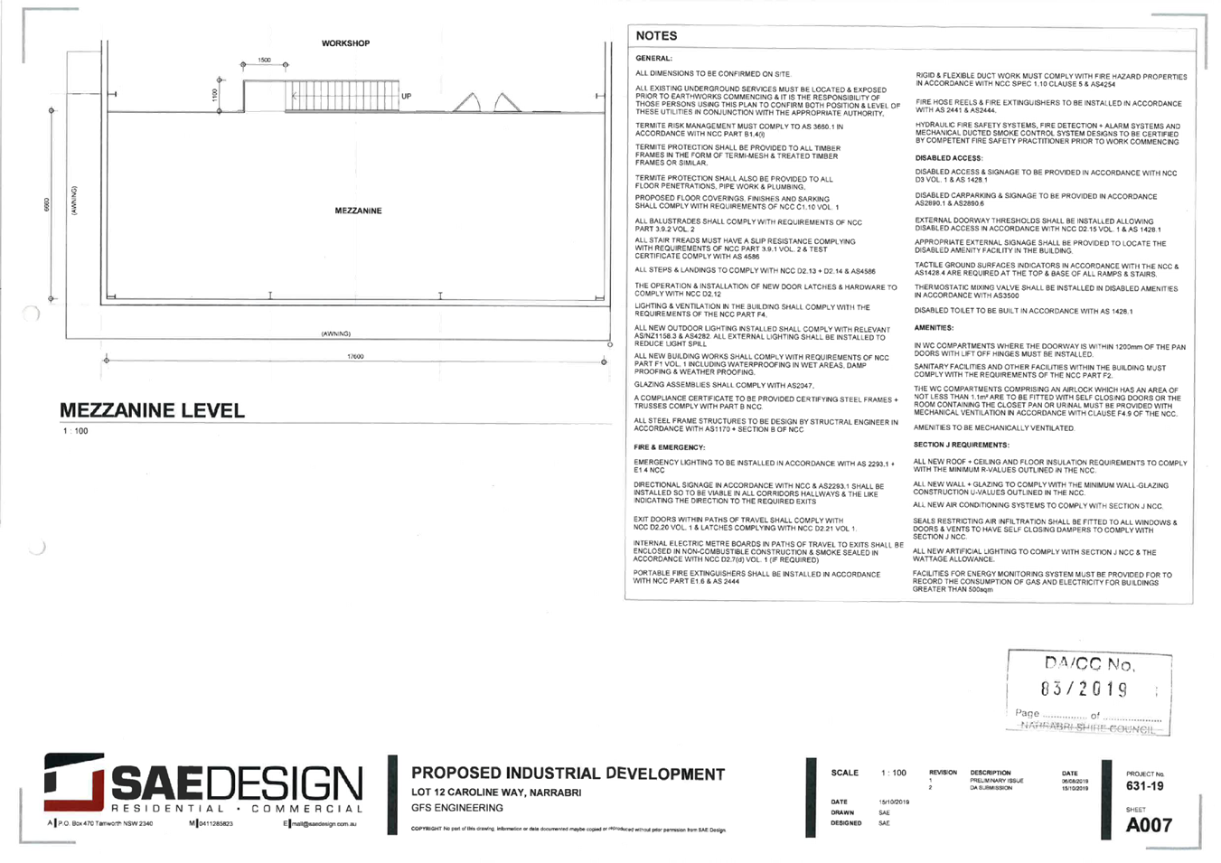
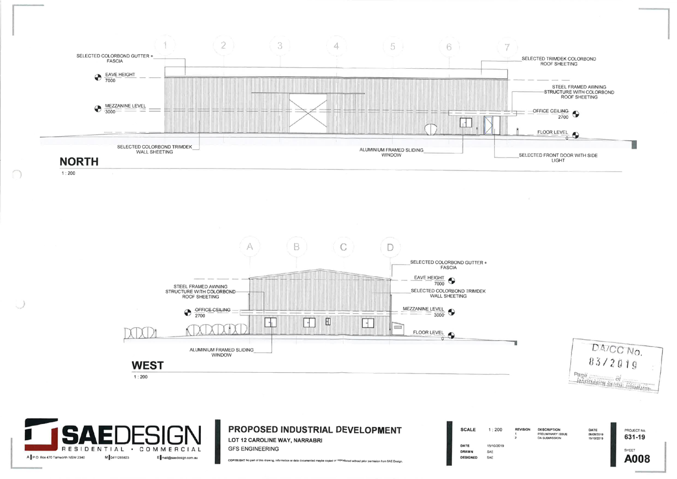
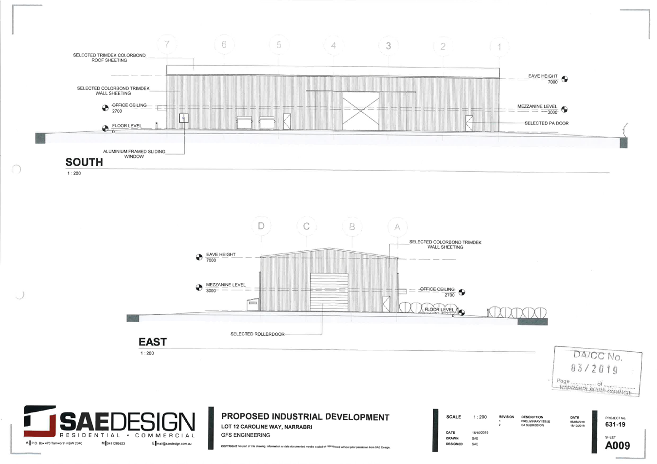
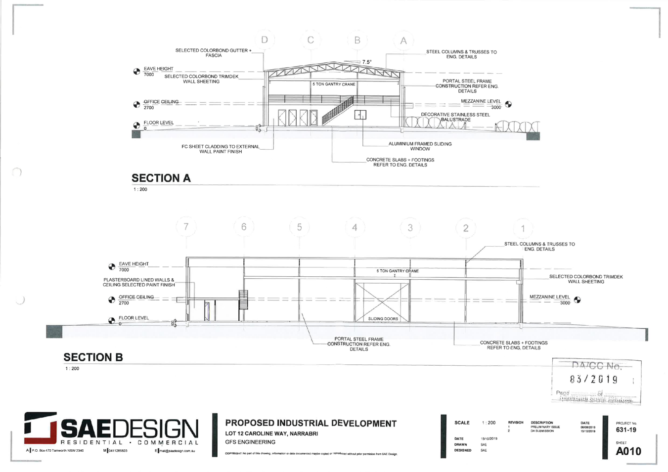
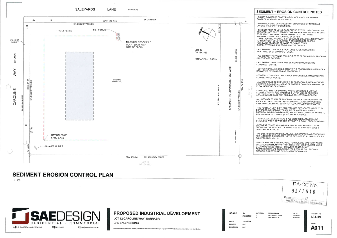
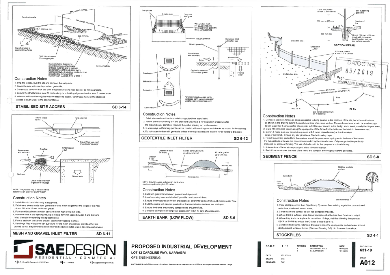
7.1 Development Application 83/2019 - Proposed Erection of industrial building for use as metal fabrication and associated office
Responsible Officer: Daniel Boyce, Director Development and Economic Growth
Author: Daniel Boyce, Director Development and Economic Growth
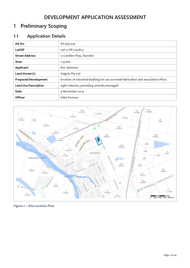
APPLICATION DETAILS
Applicant: Roz Solomon
Owner: Solgale Pty Ltd
Proposal: Erection of industrial building for use as metal fabrication and associated office.
Location: Lot 12 DP 1242823, 12 Caroline Way, Narrabri
Attachments: 1. Development Assessment Report and draft conditions ⇩
2. Proposed development plans ⇩
|
1. That Council determine the Development Application 83/2019 for the erection of an industrial building for use as metal fabrication and associated office by granting consent to the application subject to conditions in Attachment 1. 2. That Council release the following restrictions on the use of land on Lot 12 DP 1242823: a. Development limitation to 20% site coverage (fill and construction of buildings) 3. That Council apply the following restrictions on the use of land on Lot 12 DP 1242823: a. Development (fill and construction of buildings) requires a flood impact assessment demonstrating that the cumulative flood level increases are within the acceptable limits identified in the Narrabri Supplementary Floodplain Management Study by Osborne Lane and Max Winders and Associates dated February 2002. |
Proposal
The proposed development is the erection of an industrial building for use as metal fabrication and associated office.
Reason for consideration by Council
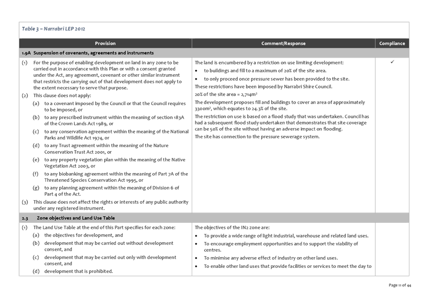
The land is encumbered by a restriction on use limiting development:
· to buildings and fill to a maximum of 20% of the site area.
· to only proceed once pressure sewer has been provided to the site.
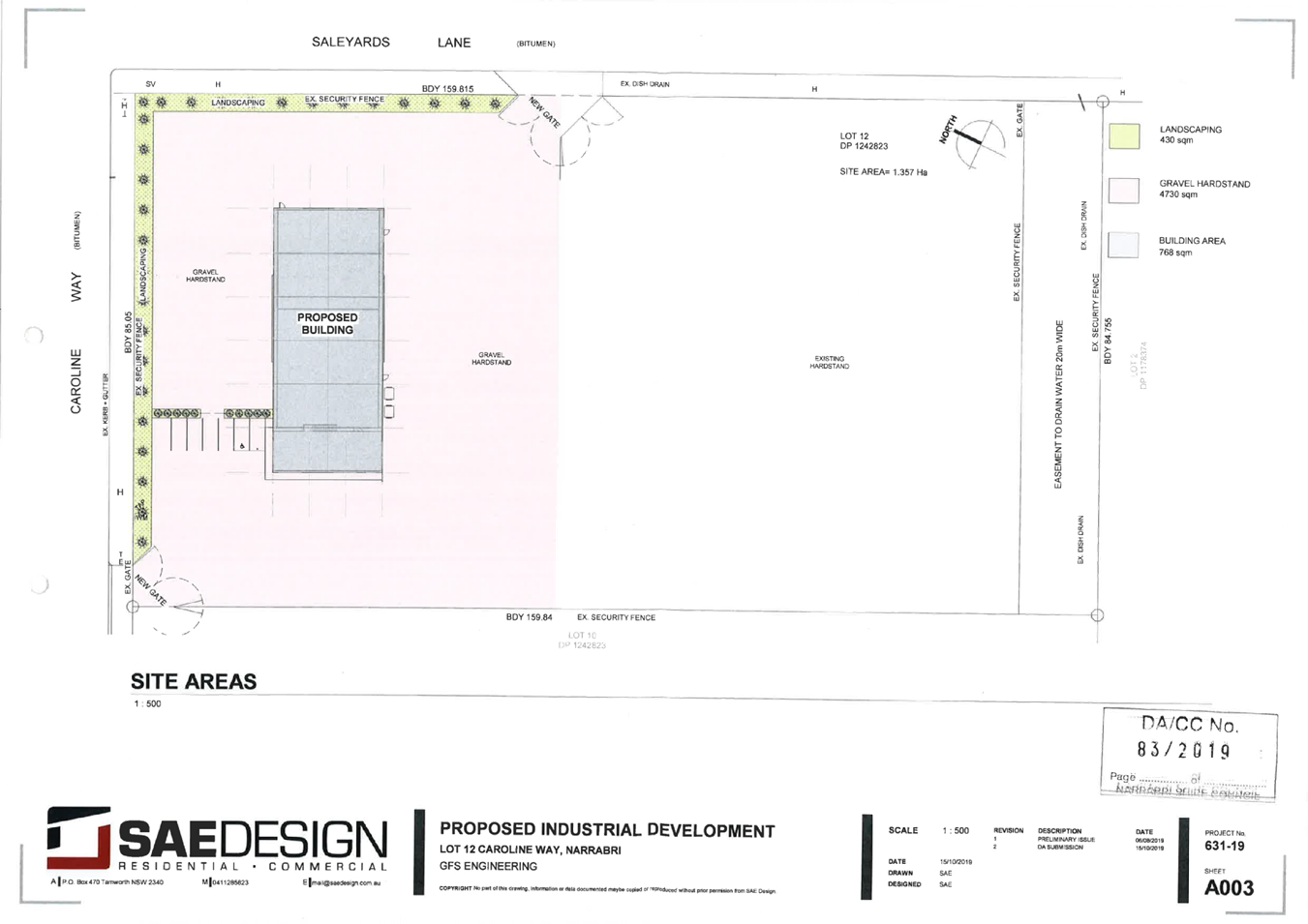
The development proposes fill and buildings to cover an area of approximately 3,300m², which equates to 24.3% of the site.
Permissibility
The land is zoned IN2 Light Industrial pursuant to Narrabri Local Environmental Plan 2012 (“LEP 2012”). The development is categorised as a ‘Light Industry’ given the context of the neighbourhood and the application of a condition setting appropriate emission thresholds and is permissible in the zone with development consent.
Consultation
There is no requirement to notify the development.
Main issues
The main issues arising from the assessment are:
· Flood Hazard and Impact
· Covenants
Conclusion
The development has been assessed with regard to the relevant prescribed matters for consideration outlined in Section 4.15 of the Environmental Planning & Assessment Act 1979 (“EPA Act”) (Attachment 1).
The development is permissible with consent and will ultimately serve the objectives of the IN2 zone. Weight must be given to the zoning in the “resolution of a dispute as to the appropriate development” of the land.
The development is a suitable use of the land having regard to the flood conditions.
The development complies with the relevant planning instruments.
With the imposition of the recommended conditions the development will not have any unacceptable impacts on the surrounding area, environment and adjoining development.
Background
Existing Sites Features and Surrounding Development
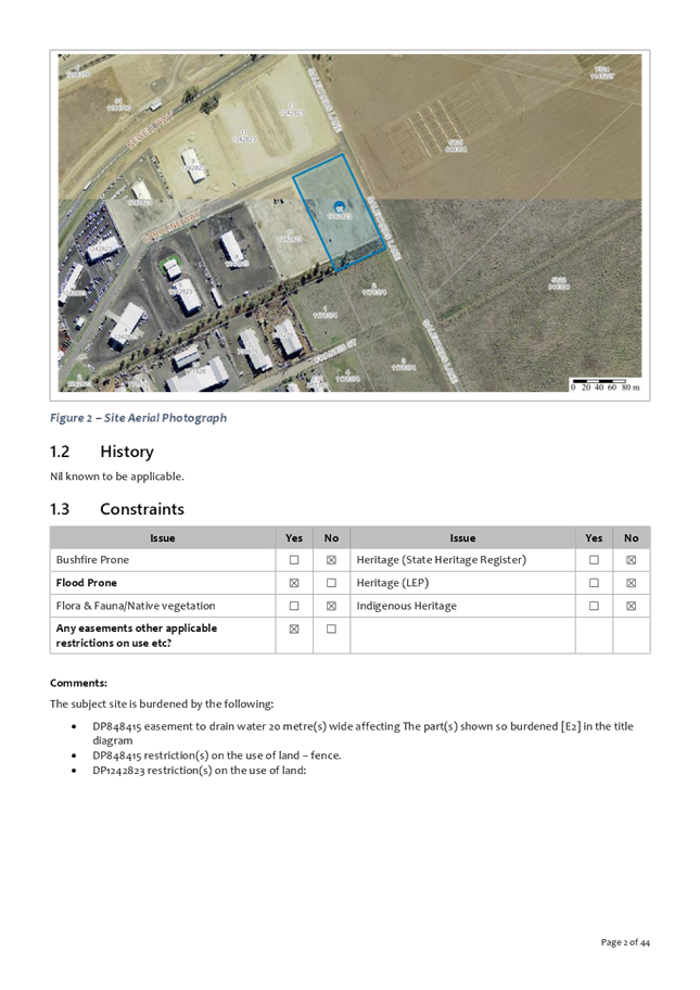
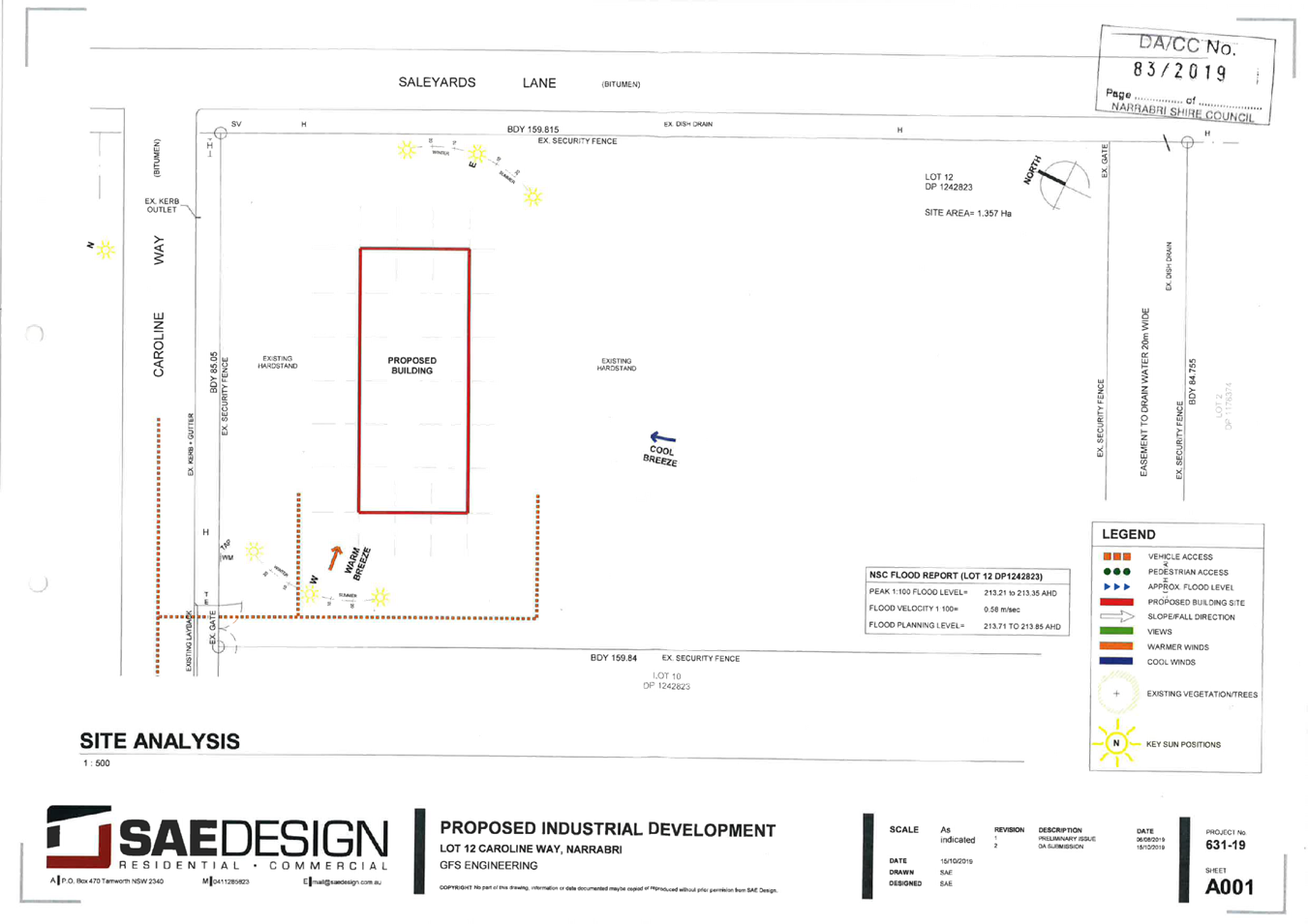
Lot 12 DP 1242823, 12 Caroline Way, Narrabri (“the Land”) is zoned IN2 Light Industrial pursuant to LEP. The Land is surrounded by industrial development on both the western and eastern sides of the Newell Highway and is affected by flood from both the Mulgate Creek and Namoi River systems.
Development History
Lot 12 DP 1242823 was created via a subdivision approved by Council under DA95/2017 on 7 September 2017.
Description of Proposal
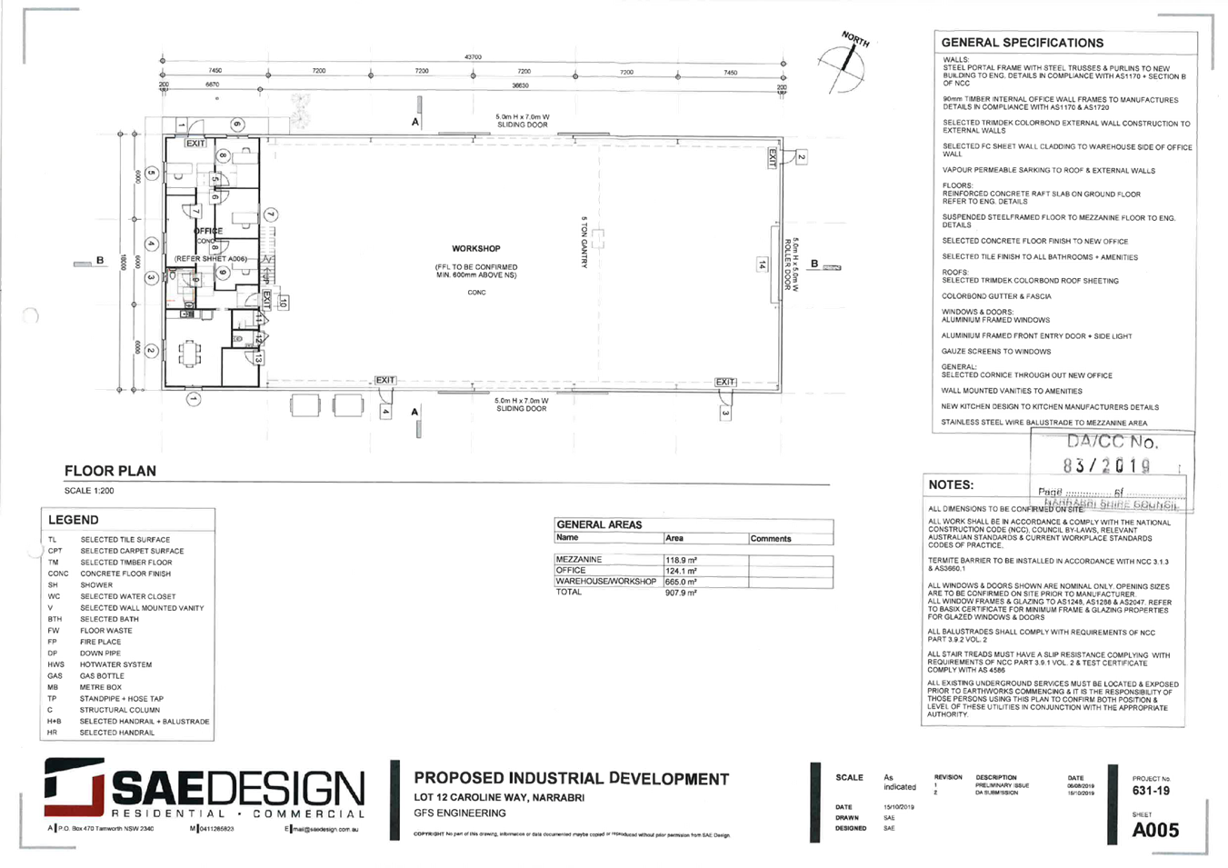
The proposal comprises:
· Construction of a new building, containing Workshop (665sqm) + Office space (124sqm)
· A mezzanine above the new office area will be utilized for storage (124sqm)
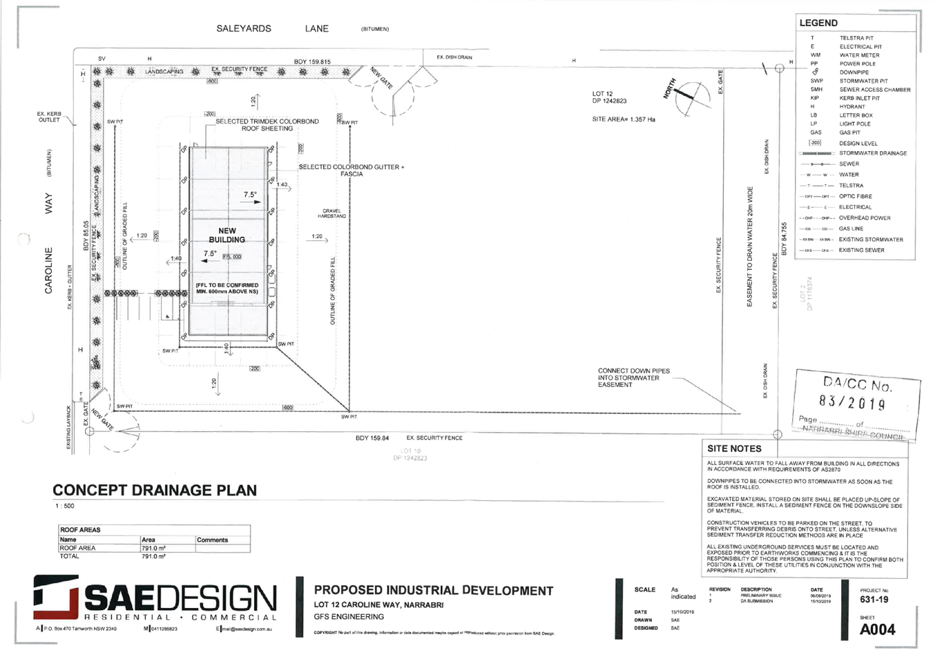
· The new building will be metal clad Colorbond sheeting structure supported by steel frame with steel roof
· New gravel hardstand area around the perimeter of the building
· New concrete hardstand pad for disabled carpark
· The site will add an additional driveway, total of 2, to allow vehicles to enter and exit in a forward direction
· A new carparking will be provided at the front of the new building to allow direct access for staff + visitor parking
· Utilise existing services on the site including water, sewer, stormwater and electricity
The development is categorised as a ‘Light Industry’ given the context of the neighbourhood and the application of a condition setting appropriate emission thresholds and is permissible in the zone with development consent.
Social Impacts
Council must take into consideration in so far as is relevant to the proposed development the likely impacts of that development, including (amongst other things) the social impacts in the locality (Farrier & Stein, 2016).
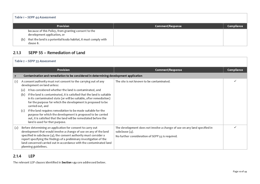
The NSW Planning & Environment’s Social impact assessment guideline: for state Significant Mining, Petroleum Production and Extractive Industry Development (NSW Government Planning & Environment, 2017) has been used as a guide to consider potential social impacts from the proposed development. It identifies that social impacts can involve changes to the matters outlined in the following table. Table 1 provides consideration of these matters in relation to the proposed development.
Table 1 Social Impact Consideration
|
Matter |
Consideration |
|
Way of Life |
· The development is not expected to impact upon how people live (e.g. how they get around or access to adequate housing). · The development is not expected to impact upon how people play. · The development is not expected to impact how people interact with one another on a daily basis. |
|
Community |
The development is not likely to impact on the composition, cohesion, or character of the community, or how it functions or sense of place. |
|
Access to and use of infrastructure, services and facilities |
The development is not likely impact upon the access to and use of infrastructure, services and facilities provided by local, state, or federal governments, or by for‐profit or not‐for‐profit organisations or volunteer groups. |
|
Culture |
The development is not expected to adversely impact upon culture including shared beliefs, customs, values and stories, and connections to land, places, and buildings (including Aboriginal culture and connection to country). |
|
Health and Wellbeing |
The development is not expected to adversely impact on health and wellbeing, including both physical and mental health. |
|
Surroundings |
The development is not expected to adversely impact on the surroundings including access to and use of ecosystem services, public safety and security, access to and use of the natural and built environment, and its aesthetic value and/or amenity. |
|
Personal and property rights |
The development is not expected to have an unreasonable impact on personal or property rights. |
|
Decision making systems |
The development is not expected to impact on decision making systems. |
|
Fears and aspirations |
The development is not expected to impact on fears and aspirations. |
Economic impacts
Council must take into consideration the economic impacts of the development in the locality (Farrier & Stein, 2016).
No adverse economic impacts expected in the locality.
Public Interest
Council must take into consideration in so far as is relevant “the public interest”.
The public interest is served through achieving the relevant objects of the EPA Act (Section 1.3). Table 2 assesses the proposed development against the objects of the EPA Act.
Table 2 Assessment against the Objects of the EPA Act
|
Object |
Comment |
|
(a) to promote the social and economic welfare of the community and a better environment by the proper management, development and conservation of the State’s natural and other resources, |
N/A. |
|
(b) to facilitate ecologically sustainable development by integrating relevant economic, environmental and social considerations in decision-making about environmental planning and assessment,
|
The economic, environmental and social impacts have been assessed and are considered to be acceptable. |
|
(c) to promote the orderly and economic use and development of land, |
The land is vacant and zoned for the purpose for which the development is proposed. |
|
(d) to promote the delivery and maintenance of affordable housing, |
N/A. |
|
(e) to protect the environment, including the conservation of threatened and other species of native animals and plants, ecological communities and their habitats, |
The development will not significantly affect threatened species or ecological communities, or their habitats. |
|
(f) to promote the sustainable management of built and cultural heritage (including Aboriginal cultural heritage), |
The site is not mapped as containing any items of European Heritage. An AHIMS search carried out did not identify any items or Aboriginal sites have been recorded in or near the site. However a condition has been imposed requiring works to cease and OEH to be contacted should any items suspected of being Aboriginal in origin discovered during works. |
|
(g) to promote good design and amenity of the built environment, |
The building has been designed appropriately for an industrial zone. |
|
(h) to promote the proper construction and maintenance of buildings, including the protection of the health and safety of their occupants, |
The building will comply with the National Construction Code. |
|
(i) to promote the sharing of the responsibility for environmental planning and assessment between the different levels of government in the State, |
This “local development” has undergone a merit based assessment by Council Staff and will be determined by the elected Council. |
|
(j) to provide increased opportunity for community participation in environmental planning and assessment. |
This “local development” has not been notified to adjoining properties, however, the LEP underwent extension public participation and the development is consistent with the zone objectives. |
Statutory Assessment
The development is defined as a ‘Light Industry’ given the context of the neighbourhood and the application of a condition setting appropriate emission thresholds and is permissible in the zone with development consent.
The objectives of the IN2 zone are:
· To provide a wide range of light industrial, warehouse and related land uses.
· To encourage employment opportunities and to support the viability of centres.
· To minimise any adverse effect of industry on other land uses.
· To enable other land uses that provide facilities or services to meet the day to day needs of workers in the area.
· To support and protect industrial land for industrial uses.
The development is considered to be consistent with the zone objectives.
Section 4.15 Assessment
The development has been assessed with regard to the relevant prescribed matters for consideration outlined in Section 4.15 of the EPA Act (Attachment 1).
Main Issues
The main issues arising from the assessment are:
· Flood Hazard and Impact
· Covenants
Covenants
The land is encumbered by a restriction on use limiting development:
· to buildings and fill to a maximum of 20% of the site area.
· to only proceed once pressure sewer has been provided to the site.
The development proposes fill and buildings to cover an area of approximately 3300m², which equates to 24.3% of the site.
The purpose of the limitation to 20% site coverage was to ensure that flood impacts from development on the lots were within acceptable limits. The flood impact is discussed below, however, it is proposed to replace the restrictions with a performance-based restriction requiring future development to be accompanied by a site specific flood study:
· Development (fill and construction of buildings) requires a flood impact assessment demonstrating that the cumulative flood level increases are within the acceptable limits identified in the Narrabri Supplementary Floodplain Management Study by Osborne Lane and Max Winders and Associates dated February 2002.
An existing sewer junction is available for connection on the Caroline Way side of the property (north-west corner).
Flood Hazard and Impact
According to the Australian Disaster Resilience Handbook 7 Managing the Floodplain: A Guide to Best Practice in Flood Risk Management in Australia (AIDR Handbook 2017):
Maintaining the flood function of the floodplain is a key objective of best practice in flood risk management in Australia, because it is essential to managing flood behaviour. The flood function of areas of the floodplain will vary with the magnitude in an event. In general flood function is examined in the defined flood event, so it can be maintained in this event (p. 30).
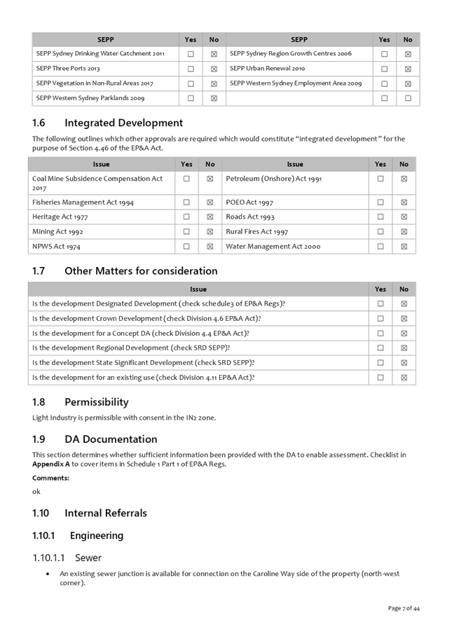
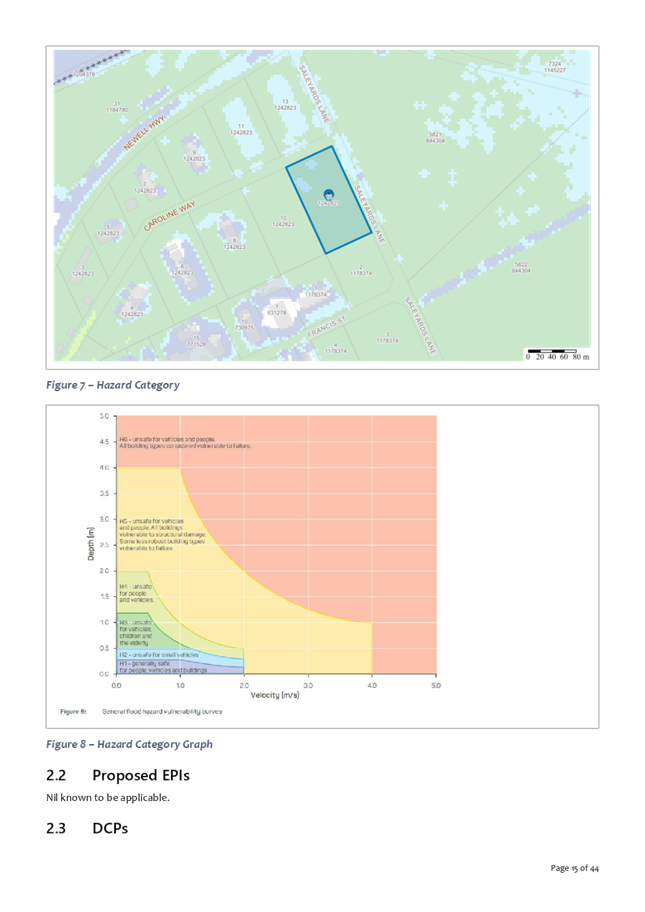
Figure 1 identifies the flood function of the Land in the 1% AEP flood (the defined flood event for planning purposes).
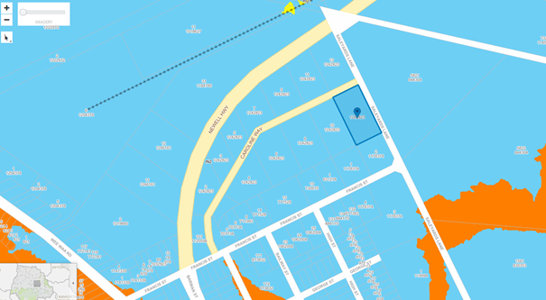
Figure 1 Flood function in the 1% AEP flood (Blue – Flood Storage, Orange – Floodway)
According to the AIDR Handbook 2017:
Flood storage areas are the parts of the floodplain that are important for temporary storage of floodwaters during a flood passage. The loss of flood storage can increase the severity of flood impacts by reducing natural flood attenuation (p. 86).
Australian Disaster Resilience Guideline 7-5 Flood Information to Support Land-use Planning (AIDR Guideline 2017):
Filling of flood storage areas reduces their ability to attenuate downstream flood flows and, as a result, flood flows and flood levels may increase.
The Narrabri Supplementary Floodplain Management Study by Osborne Lane and Max Winders and Associates dated February 2002 (“the 2002 Flood Study”) set a limitation of 20% site coverage to ensure that flood impacts from development on the lots were within acceptable limits.
The Narrabri Industrial Area Flood Options Assessment by WRM Water and Environment (“Options Assessment”) based on its 2D model for the Namoi River System at Narrabri was prepared to investigate increased density in parts of Caroline Way to 50%.
For Mulgate Creek flooding:
· There are localised increases in flood levels of greater than +0.3 m to the north of Caroline Way for the 20%, 10%, 5%, 2% and 1% AEP events;
· Mulgate Creek floodwaters are diverted westwards across the Newell Highway towards undeveloped agricultural land during the 2% and 1% AEP events, resulting in increased flood levels of up to +0.4 m.
For Namoi River flooding:
· There are highly localised increases of flood levels, up to +0.05 m in the immediate vicinity of the proposed development areas, however these increases do not appear to impact on other developments or residential properties.
In addition to assessing the impact of the development on flood function the proposed land use must be compatible with the flood hazard. According to the AIDR Guideline 2017:
Flood hazard classification provides a description of how hazardous the physical conditions produced by a flood can be, independent of the population at risk. It is typically based on benchmarking the depth and velocity of the floodwaters against thresholds to determine how hazardous this combination may be to people, cars, infrastructure and buildings, if they were exposed to the flooding.
It recommends grouping the floodplain into the following categories:
· H1—generally safe for people, vehicles and buildings
· H2—unsafe for small vehicles
· H3—unsafe for vehicles, children and older people
· H4—unsafe for all people and vehicles
· H5—unsafe for vehicles and people, and all buildings are vulnerable to structural damage
· H6—unsafe for vehicles and people, and all building types are vulnerable to structural failure.
The likely 1% AEP flood depths and velocities at the building site are 0.63 m and 0.47 m/sec respectively.
The expected depth and velocity combination lies inside the H3 category, determined to be unsafe for vehicles, children and the elderly (Figure 2). The expected depth and velocity combination present a moderate hazard for adults (Figure 3). The expected depth and velocity combination present a low hazard to structures (Figure 4).
![]()
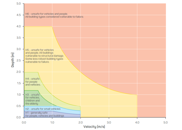
Figure 2 General Flood Hazards (Australian Disaster Resilience Guideline 7-3
Flood Hazard).
![]()
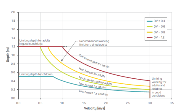
Figure 3 Thresholds for people stability in floods (Australian Disaster Resilience Guideline 7-3 Flood Hazard).
![]()
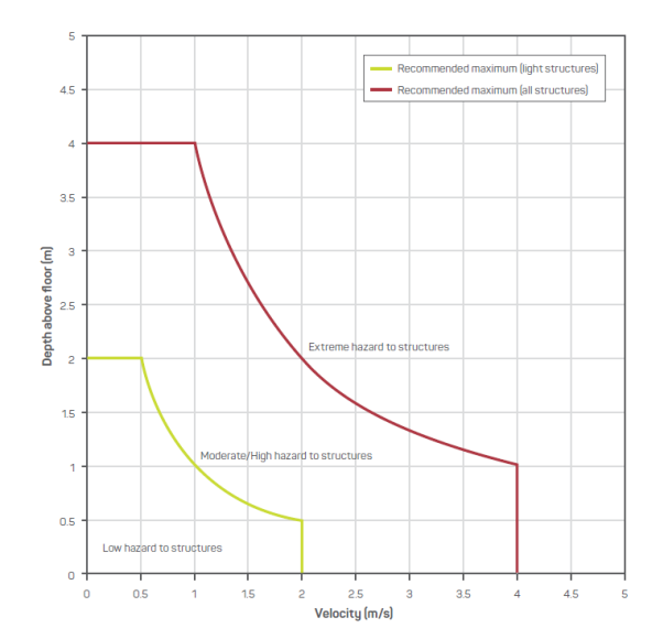
Figure 4 Thresholds for building stability in floods (Australian Disaster Resilience Guideline 7-3 Flood Hazard).
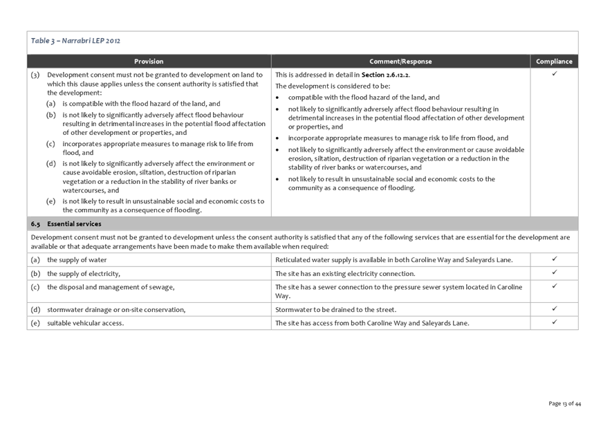
The proposed development is in accordance with Clause 6.2 of the LEP (Table 3).
Table 3 Assessment against Clause 6.2 of the Narrabri Local Environmental Plan 2012
|
(3) Development consent must not be granted to development on land to which this clause applies unless the consent authority is satisfied that the development: |
Staff Comment |
|
(a) is compatible with the flood hazard of the land, and |
The expected depth and velocity combination lies inside the H3 category, determined to be unsafe for vehicles, children and the elderly (Figure 2). The expected depth and velocity combination present a moderate hazard for adults (Figure 3) and a low hazard to structures (Figure 4). |
|
(b) is not likely to significantly adversely affect flood behaviour resulting in detrimental increases in the potential flood affectation of other development or properties, and |
The Options Assessment indicates the cumulative impact of a 50% site coverage do not appear to impact on other developments or residential properties. |
|
(c) incorporates appropriate measures to manage risk to life from flood, and |
The risk to life will be managed by applying a minimum floor level above the 1% AEP flood. The Namoi River is a large river system with a long response time and accordingly, there are ample opportunities to evacuate the site prior to the arrival of the flood peak. |
|
(d) is not likely to significantly adversely affect the environment or cause avoidable erosion, siltation, destruction of riparian vegetation or a reduction in the stability of river banks or watercourses, and |
The proposed development is set back from the river bank, outside waterfront land with low associated environmental impact. |
|
(e) is not likely to result in unsustainable social and economic costs to the community as a consequence of flooding |
The proposal represents an appropriate use that is compatible with the site’s flood behaviour and is therefore consistent with the principle outlined in the floodplain development manual that encourages appropriate use (as opposed to sterilisation) of flood prone land. Subject to the recommended conditions of consent the flood hazard and impact on flood behaviour can be satisfactorily managed and the social and economic costs can be mitigated. |
Submissions
No submission received.
Land and Environment Court Planning Principles
Non-statutory regional planning policies
In Direct Factory Outlets Homebush v Strathfield Municipal Council [2006] NSWLEC 318, Senior Commissioner Roseth of the Land and Environment Court stated (at [25-26]):
The role of regional planning policies is to guide the development of a region, such as the Sydney metropolitan area. One of their functions is to inform and influence statutory plans for the local areas of a region. Regional planning policies provide a sense of purpose and direction to local plans; they are, as it were, the glue that binds local plans together. The fact that they are non-statutory is not an indication of their subservience to statutory plans. Planning policies usually do not lend themselves to statutory expression because they do not relate to specific parcels of land and do not contain numerical development standards. This fact, however, does not mean that they have no relevance to individual development applications, particularly those that have impacts extending beyond the local area (at [25]).
Where the provisions of an environmental planning instrument are clear, unequivocal and do not require value judgment (for example numerical development standards or zonings where the character of a use is not in dispute), they take precedence over non-statutory regional planning policies. However, where those provisions can be applied only on the basis of value judgments (for example, where the character of a use is in dispute, a development standard is to be varied, or where imprecise terms like “appropriate”, significant”, “detrimentally affect” or “ecological sustainability” need to be given meaning in the context of a development application, non-statutory regional planning policies provide the background against which those value judgments should be made (at [26]).
Consideration of regional (and local) non-statutory planning policies is appropriate in the assessment of this development application given that certain impacts will extend beyond the immediate locality.
New England North West Regional Plan 2036
The New England North West Regional Plan 2036 (“Regional Plan”) will guide the NSW Government’s land use planning priorities and decisions to 2036. Priorities for each council are set out in Local Government Narratives, which will guide further investigations and implementation (NSW Government Planning & Environment, 2019).
Supporting economic diversification and strengthening is a priority for Narrabri under the Regional Plan (NSW Government Planning & Environment, 2019).
Community Strategic Plan Narrabri Shire 2027
The Community Strategic Plan Narrabri Shire 2027 (“Strategic Plan”) presents the community endorsed vision and strategic plan for Narrabri Shire and has been informed through extensive community engagement (Narrabri Shire Council, 2017).
The community aspires to “a strong, diverse economy that attracts, retains and inspires business industry and tourism growth” (Narrabri Shire Council, 2017).
Zones (Development at zone interface)
In Stockland Development Pty Ltd v Manly Council [2004] NSWLEC 472 Commissioner Bly stated (at [25]):
As a matter of principle, at a zone interface as exists here, any development proposal in one zone needs to recognise and take into account the form of existing development and/or development likely to occur in an adjoining different zone. In this case residents living in the 2(b) zone must accept that a higher density and larger scale residential development can happen in the adjoining 2(c) or 2(d) zones and whilst impacts must be within reason they can nevertheless occur. Such impacts may well be greater than might be the case if adjacent development were in and complied with the requirements of the same zone. Conversely any development of this site must take into account its relationship to the 2(b) zoned lands to the east, south-east, south and south-west and the likely future character of those lands must be taken into account. Also in considering the likely future character of development on the other side of the interface it may be that the development of sites such as this may not be able to achieve the full potential otherwise indicated by applicable development standards and the like (at [25]).
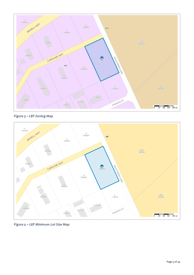
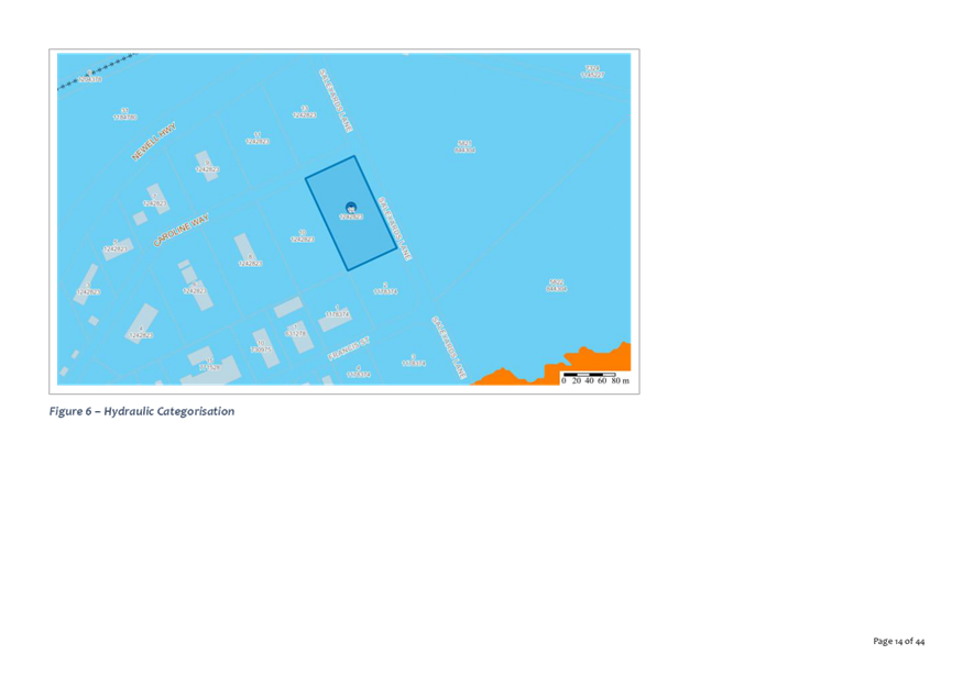
The Land is located at the interface of two zones (IN2 Light Industrial zone and RU1 Primary Production zone) (Figure 6).
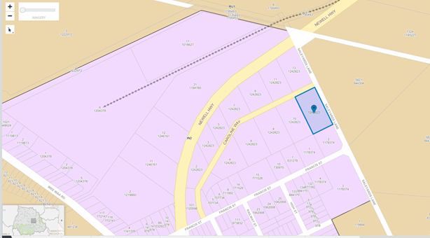
Figure 5 Zone map
The objectives of the IN2 zone are:
· To provide a wide range of light industrial, warehouse and related land uses.
· To encourage employment opportunities and to support the viability of centres.
· To minimise any adverse effect of industry on other land uses.
· To enable other land uses that provide facilities or services to meet the day to day needs of workers in the area.
· To support and protect industrial land for industrial uses
The objectives of the RU1 zone are:
· To encourage sustainable primary industry production by maintaining and enhancing the natural resource base.
· To encourage diversity in primary industry enterprises and systems appropriate for the area.
· To minimise the fragmentation and alienation of resource lands.
· To minimise conflict between land uses within this zone and land uses within adjoining zones.
· To allow for non-agricultural land uses that will not restrict the use of other land for agricultural purposes.
The proposed development is not incompatible with the primary production land uses likely to occur on the adjoining RU1 land.
Zones (Weight to be given to the zoning)
When a planning instrument provides that development for a particular purpose is permissible provided that development consent is first obtained, there is a presumption that some version of that development will be approved (albeit subject, perhaps, to stringent conditions) (Farrier & Stein, 2016).
In BGP Properties Pty Ltd v Lake Macquarie City Council [2004] NSWLEC 399, the Chief Judge of the Land and Environment Court stated:
In the ordinary course, where by its zoning land has been identified as generally suitable for a particular purpose, weight must be given to that zoning in the resolution of a dispute as to the appropriate development of any site. Although the fact that a particular use may be permissible is a neutral factor (see Mobil Oil Australia Ltd v Baulkham Hills Shire Council (No 2) [1971] 28 LGRA 374 at 379), planning decisions must generally reflect an assumption that, in some form, development which is consistent with the zoning will be permitted (at [117]).
The land is zoned IN2 Light Industrial and the development is permissible with consent in the zone. Weight must be given to the IN2 zoning in the “resolution of a dispute as to the appropriate development” of the land.
General impact
In Davies v Penrith City Council [2013] NSWLEC 1141, Senior Commissioner Moore of the Land and Environment Court stated (at [121]):
I have, therefore, undertaken the internal consultation process for consideration of the establishment of a new planning principle or the revision of an existing planning principle. As a result of that consultation, it is appropriate to refine the published planning principle to delete the words "necessary and/or" so that the revised planning principle will, in future, read:
Revised planning principle: criteria for assessing impact on neighbouring properties
The following questions are relevant to the assessment of impacts on neighbouring properties:
· How does the impact change the amenity of the affected property? How much sunlight, view or privacy is lost as well as how much is retained?
· How reasonable is the proposal causing the impact?
· How vulnerable to the impact is the property receiving the impact? Would it require the loss of reasonable development potential to avoid the impact?
· Does the impact arise out of poor design? Could the same amount of floor space and amenity be achieved for the proponent while reducing the impact on neighbours?
· Does the proposal comply with the planning controls? If not, how much of the impact is due to the non-complying elements of the proposal? (at [121]).
Table 4 Assessment against the “General impact” Planning Principle
|
Planning principle |
Staff Comment |
|
How does the impact change the amenity of the affected property? How much sunlight, view or privacy is lost as well as how much is retained? |
The development does not unreasonably impact amenity of development in the locality. |
|
How reasonable is the proposal causing the impact? |
The development is a permissible form of development with acceptable impacts from a flood perspective. It is therefore considered reasonable. |
|
How vulnerable to the impact is the property receiving the impact? Would it require the loss of reasonable development potential to avoid the impact? |
The more sensitive region to the proposed development is the existing industrial development on the eastern side of the highway, particularly around Caroline Way. The Flood Assessment indicates the cumulative The Options Assessment indicates the cumulative impact of a 50% site coverage do not appear to impact on other developments or residential properties. |
|
Does the impact arise out of poor design? Could the same amount of floor space and amenity be achieved for the proponent while reducing the impact on neighbours? |
The development has been designed to balance to the need to address flood risk to the development itself as well as the need to limit flood impacts on adjoining development, in particular the existing industrial development on the eastern side of the highway. |
|
Does the proposal comply with the planning controls? If not, how much of the impact is due to the non-complying elements of the proposal? |
The proposal complies with local planning controls. The following restrictions on the use of land apply: · to buildings and fill to a maximum of 20% of the site area. The development proposes fill and buildings to cover an area of approximately 3300m², which equates to 24.3% of the site. The purpose of the limitation to 20% site coverage was to ensure that flood impacts from development on the lots were within acceptable limits. The flood impact is discussed below, however, it is proposed to replace the restrictions with a performance-based restriction requiring future development to be accompanied by a site specific flood study: · Development (fill and construction of buildings) requires a flood impact assessment demonstrating that the cumulative flood level increases are within the acceptable limits identified in the Narrabri Supplementary Floodplain Management Study by Osborne Lane and Max Winders and Associates dated February 2002. |
Surrounding development
In Project Venture Developments v Pittwater Council [2005] NSWLEC 191, Senior Commissioner Roseth of the Land and Environment Court stated (at [22 and 24]):
There are many dictionary definitions of compatible. The most apposite meaning in an urban design context is capable of existing together in harmony. Compatibility is thus different from sameness. It is generally accepted that buildings can exist together in harmony without having the same density, scale or appearance, though as the difference in these attributes increases, harmony is harder to achieve (at [22]).
Where compatibility between a building and its surroundings is desirable, its two major aspects are physical impact and visual impact. In order to test whether a proposal is compatible with its context, two questions should be asked.
· Are the proposal’s physical impacts on surrounding development acceptable? The physical impacts include constraints on the development potential of surrounding sites.
· Is the proposal’s appearance in harmony with the buildings around it and the character of the street? (at [24]).
Table 5 Assessment against the “Surrounding development” Planning Principle
|
Planning principle |
Staff Comment |
|
Are the proposal’s physical impacts on surrounding development acceptable? The physical impacts include constraints on the development potential of surrounding sites. |
The development is a permissible form of development with acceptable impacts from an amenity and flood perspective. It does not unreasonably constrain the development potential of surrounding sites. |
|
Is the proposal’s appearance in harmony with the buildings around it and the character of the street? |
The development appearance is in harmony the buildings around it and the character of the street by virtue of having a similar appearance to other industrial buildings in the street. |
Public Participation
The DA was not required to be notified or advertised.
Referrals
Infrastructure Delivery (Internal)
The DA was referred to Council’s Infrastructure Delivery Department (“Infrastructure”). Infrastructure comments are summarised in section 1.10 Internal Referrals of the Development Assessment Report (Attachment 1).
Development Contributions Applicable
Fixed development consent levy.
Conclusion
Development Application 83/2019 has been assessed in accordance with Section 4.15 of the EPA Act and can be determined by way of approval subject to conditions (Attachment 1) for the following reasons:
Reasons for the decision
1. The development is permissible with consent in the IN2 zone and consistent with the objectives for development in the IN2 zone.
2. The development is a suitable use of the land.
3. The development complies with the relevant planning instruments.
4. With the imposition of the recommended conditions the development will not have any unacceptable impacts on the surrounding area, environment and adjoining development.
5. The development is in the public interest because:
a) It is consistent with the relevant objects of the EPA Act.
b) It is consistent with the New England North West Regional Plan 2036.
c) It is consistent with Community Strategic Plan Narrabri Shire 2027.
References
Farrier, D., & Stein, P. (2016). The environmental law handbook (6th ed.). Rozelle, N.S.W.: Thomson Reuters (Professional) Australia Limited.
NSW Government Planning & Environment. (2019). New England North West Regional Plan 2036.
Narrabri Shire Council. (2017). Community Strategic Plan Narrabri Shire 2027.